Due Diligence & Market Analysis
Can I acquire it, hold it, and what will it cost me?
For ground we secure, and ground offered in a deal: titles and applications, native title and land access, environment, geology and the exploration record, and what it costs to acquire, hold and test.
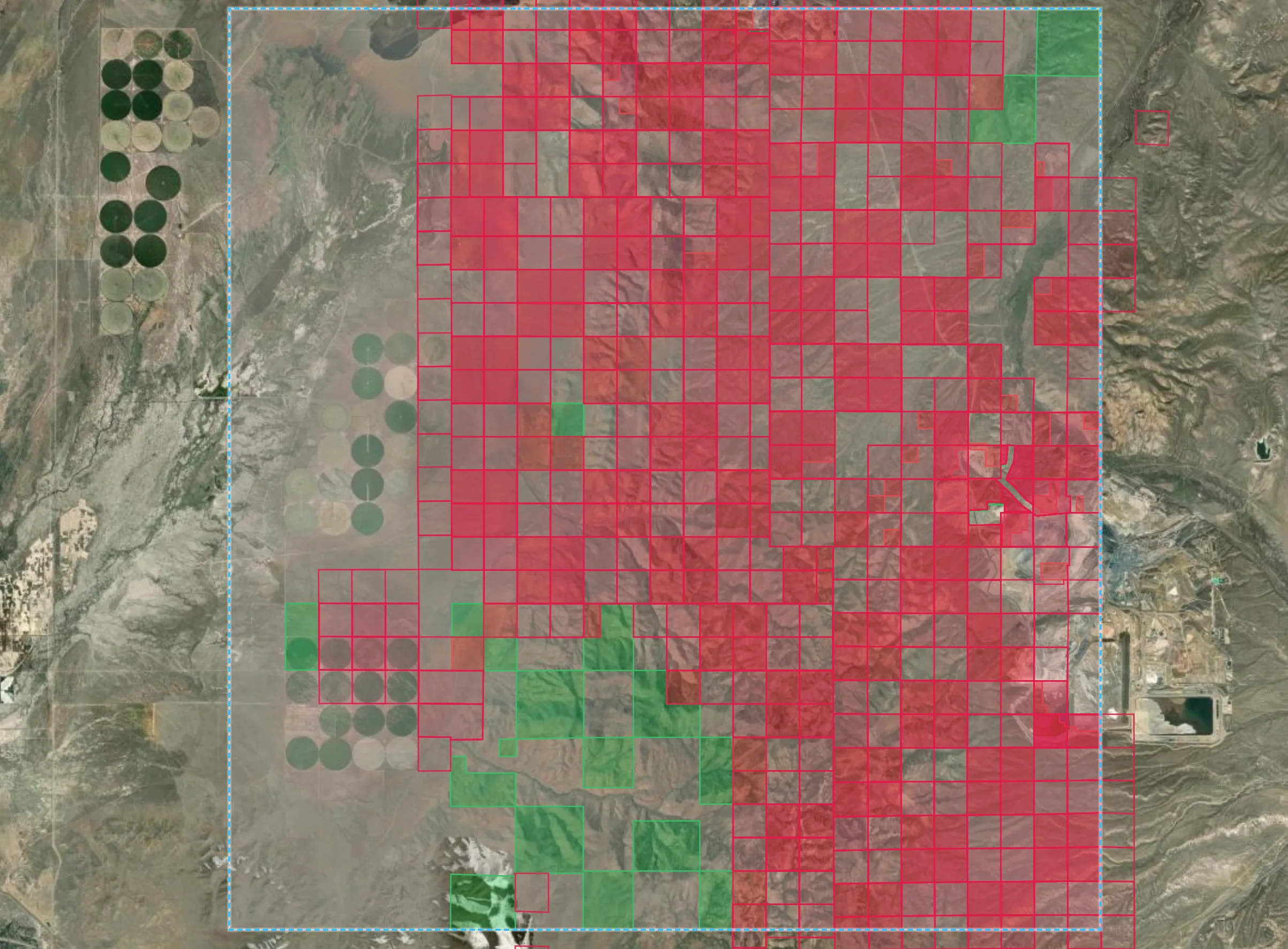
Carlin Trend, Nevada: federal land classified from the live claim register, with active mining claims in red against open federal ground in green, and an operating mine at the eastern edge.































Data published by 80 organisations ·Names and logos belong to their owners; no endorsement or partnership is implied. All 80 sources
The problem
A register snapshot that looks current is the most expensive kind of wrong.
A register extract fetched this year can still describe permits that expired years ago, and nothing in the file says so. We query tenure live at the moment of assessment, date every other layer, and give no verdict from a failed input.
- 8
- Report sections
- Deterministic: the same inputs always give the same report
- Live
- Tenure
- Queried against the register at assessment time
- AU · US
- Deepest coverage
- Queensland end to end; federal land in Nevada; national Australian layers everywhere
- Report + GIS
- Deliverable
- A written assessment and the layers behind it
The report
Eight sections. Every line sourced.
The same structure every time, so two areas compare side by side. In Queensland the live register reaches down to moratoria, restricted areas and abandoned workings.
On United States federal land
Ground is classed closed to mineral entry, non-federal surface, active claims, filed claim cases or open federal ground, from the live claim register. The report adds:
- Mining claims and ground availability
- Surface ownership and land survey
- Conservation designations and protected lands
- Tribal lands and cultural resources
- 01
Executive summary
The availability verdict, the caveats that attach to it, and what drives it.
- 02
Tenure and ground availability
Granted titles and applications over the area, with holder, status, expiry and overlap.
- 03
Native title and land access
Determinations, agreements and claims, and the conditions they attach.
- 04
Land: parcels, use and water
Cadastre, land use and water licences: who you will be dealing with on the ground.
- 05
Environment and compliance
Contaminated land, environmental licences and abandoned workings.
- 06
Geology
Mapped units, ages and structure, at the finest published scale.
- 07
Mineral occurrence and exploration record
Occurrences, deposits, drilling and geochemistry already on the public record.
- 08
Data inventory and provenance
Every source consulted, its publisher, its currency and its licence.
Cost and market analysis
What it costs to hold the ground, and to test it.
Holding costs read from the regulators' own instruments, drilling benchmarked from published government records. Market analysis comes the same way: a report and a working spreadsheet, every figure sourced and dated.
A$350,000
To drill-test one target
A greenfield programme, from a South Australian scheme's acquittal of 200 completed projects and 4,622 holes, in current dollars. At least A$291,000 on the most conservative reading, from Western Australian co-funding rounds.
A$402
All-in, per metre drilled
Greenfield exploration spend per metre drilled in Australia, year to June 2026, including geophysics, geochemistry and people. A$349 for brownfield work.
17 months
Median time to grant
A Queensland exploration permit, from application to grant, measured from the register. About four months where native title land is left out of the application.
Read more: holding a position in Queensland, Western Australia and on US federal land
| Queensland | Western Australia | United States, federal land | |
|---|---|---|---|
| Title | Exploration permit (minerals) | Exploration licence | Lode mining claim |
| To apply | About A$1,150 | A$1,800 per licence | US$274 per claim, including the first year's maintenance |
| Each year | Nil rent for permits granted or reaching an anniversary before 1 September 2028 | A$177 per block, years one to three | US$200 per claim |
| Spending commitment | The holder's own work programme; no statutory minimum | A$1,000 per block a year, years one to three | None for a maintained claim |
| Largest single title | 100 sub-blocks, about 300 km² | 70 blocks in known mineralised areas | 1,500 by 600 feet |
| Given up | Half the area at the end of year five | 40 per cent at the end of year six | Not applicable |
Rates as published for 2026 to 2027, read in September 2026. Queensland: Mineral Resources Regulation 2025 and the fee unit value from 1 July 2026; where native title protection conditions apply, the holder also pays the native title party an administrative payment of about A$1,558 a year. Western Australia: the Mining Act 1978 information on mining tenements. United States: 43 CFR part 3830 and the Bureau of Land Management fee schedule; county recording fees are extra. The titles are not like for like: a located claim holds the right to the minerals, while an Australian exploration title holds the right to explore and a priority to apply for a lease.
What it produces
The output.
What the engine produces, in formats a GIS and a geologist can both open.
The assessment
Eight sections, every time, with the availability verdict and its caveats up front.
Per-title overlap tables
Holder, status, expiry and land-access category: the list you take into a negotiation.
A map workspace
The classification and every fetched layer on one map, with the full record behind any feature.
Costs and benchmarks
Acquisition, holding and drilling costs from the schedules and records, as a working spreadsheet.
How an assessment is built.
- 01
Define the area
An area of interest, often handed on from an open-ground shortlist or a spectral survey.
- 02
Fetch every layer
Tenure live from the register; land access, cadastre, environment, geology and the exploration record from each publisher, each with its currency recorded.
- 03
Assess availability
Open, held, under application, moratorium or excluded, and no verdict at all if a tenure input has failed.
- 04
Cost the position
Acquisition and holding costs from the statutory schedules, and testing costs from published records.
- 05
Report
The eight-section assessment, the overlap tables, the map workspace and the data inventory.
Straight talk
What this is, and what it isn't.
We would rather say less than claim more than the evidence supports.
It is
- A deterministic assessment built from the authorities' own registers, with tenure queried live
- Explicit about gaps: a failed source is named, with its effect on the verdict
- Costs read from published schedules and records, each carrying its source and date
It is not
- Legal advice: the report names the instruments and sends you to counsel
- A resource or reserve estimate
- A substitute for a live register query on the day you peg or sign
Next in the workflow · 01
MineDSS Atlas
What is actually known about this ground?
Continue-
Partners
Exploration and mining companies interested in working with us.
-
Investors
The record, the models and the ground they point to.
-
Publishers and researchers
Geological surveys, universities and programmes whose work the record is built on.